Signed in as:
filler@godaddy.com
Behind the Front Door | Carmel, NY
The shoreline of Lake Gleneida did not always look the way it does today.
By the late nineteenth century, homes and other buildings stood along portions of the lakefront in the center of Carmel. Then New York City’s expanding water system reached Putnam County.
The Town of Carmel records that the Webster Act of 1893 resulted in many homes and buildings being moved off the lakeshore of Lake Gleneida. The West Branch Reservoir followed in 1898 and the Croton Falls Reservoir in 1911.
That means one of Carmel’s most familiar views—the open water along Gleneida Avenue—exists partly because the landscape around it was deliberately changed more than a century ago.
And that is only one piece of Carmel’s story.
Long before Route 52 carried traffic through the center of Carmel, the lake was known as Shaw’s Pond, named for early settler Timothy Shaw, who lived near its northern end. Historical accounts place Shaw there as early as the 1740s.
In 1852, local residents decided the old name was not quite grand enough for what they considered one of Carmel’s defining natural features.
A committee was formed.
Shaw’s Pond became Lake Gleneida.
By then, the community surrounding it had already taken on another important role.
Putnam County was separated from Dutchess County in 1812, and Carmel became the county seat. The original Putnam County Courthouse was completed in 1814 on land overlooking Lake Gleneida. That historic courthouse remains in the center of the hamlet today.
So government, homes, churches, businesses and community life gradually developed around the lake.
The water was part of Carmel’s identity.
Then its importance became much larger than Carmel.
By the end of the nineteenth century, New York City was dramatically expanding the system that supplied drinking water to its growing population.
Carmel happened to sit directly within that landscape.
The Town of Carmel’s own history records the turning point plainly: following the Webster Act of 1893, many homes and buildings were moved away from Lake Gleneida’s shoreline.
Think about that for a second.
These were not merely buildings that became obsolete as a neighborhood changed.
The shoreline itself was being reorganized around a water system serving people many miles away.
Land that had once functioned as ordinary private property became part of something much larger.
And Lake Gleneida was only the beginning.
The West Branch Reservoir was completed in 1898.
The Croton Falls Reservoir followed in 1911.
Together with controlled lakes including Gleneida and Gilead, they became part of the enormous watershed network supplying New York City.
Today, almost the entire Town of Carmel lies within the New York City watershed. The town contains significant portions of the West Branch and Croton Falls reservoir systems, while its streams, ponds and lakes feed additional reservoir basins downstream.
That history still matters.
Watershed regulations, land use, septic systems, drainage, environmental protections and development patterns are not abstract planning issues here. They are part of the physical reality of owning property in this part of Putnam County.
Something that began more than a century ago is not simply sitting behind glass in a museum.
It is still on the map.
This is also where the history starts explaining something that can be confusing when looking at Carmel real estate.
Carmel is both the name of a town and the name of the hamlet surrounding Lake Gleneida.
The larger Town of Carmel encompasses very different landscapes, including Carmel, Mahopac, Mahopac Falls, lake communities, commercial corridors, established subdivisions and more rural residential areas.
The town's current comprehensive plan actually maps those distinctions rather than treating Carmel as one uniform place.
And that matters when someone says:
“I’m looking at a house in Carmel.”
Which Carmel?
A property close to the historic county-seat hamlet does not necessarily function like a house near Lake Mahopac.
A subdivision home does not necessarily behave like acreage on a quieter road.
A lake-community property can raise entirely different questions than a newer home farther from the water.
The mailing address is only the beginning of the property story.
This is why I pay attention to more than bedrooms, bathrooms and square footage.
The land underneath a property has a history.
So do the roads around it.
So do the water source, septic or sewer arrangement, municipal records, approvals, survey, lot configuration and environmental conditions that may apply to it.
Two homes with similar square footage can live very differently because the properties surrounding them developed differently.
Carmel is a particularly good example.
Its settlement pattern was shaped by historic hamlets, lakes, reservoirs, transportation routes, farmland, later subdivisions and decades of residential growth.
And the watershed remains very much part of present-day Carmel. The town notes that protection of its surface water affects not only New York City’s drinking-water supply but Carmel’s own landscape, recreation and property values.
That is why property-specific research matters here.
A town-wide statistic—or an online estimate—cannot tell you all of that.
Carmel’s current real estate numbers show plenty of activity, but—as with the town itself—the headline number only tells part of the story.
During the twelve months through August 2026, 239 single-family homes closed in Carmel, compared with 181 during the comparable period a year earlier—an increase of 32%.
The rolling median sale price increased 5%, from $500,000 to $525,000.
Average market time declined from 51 days to 45 days, while sellers received an average 100% of original asking price.
Inventory remained relatively steady at 53 single-family homes compared with 52 the previous year.
Those numbers tell us something useful: Carmel has had more completed sales while maintaining pricing and relatively limited inventory.
But they still do not describe every Carmel property.
August itself illustrates why.
During August 2026, 15 single-family homes closed, compared with 12 in August 2025.
The median sale price for those August closings was $576,700, up from $502,500 a year earlier.
Yet homes took an average 44 days to sell, compared with 30 days during August 2025, and sellers received an average 97.5% of original asking price rather than 102.1%.
None of those figures contradict one another.
They describe different pieces of the market.
OneKey itself cautions that percentage changes can appear extreme when samples are
small, which is why the rolling twelve-month view is generally more useful than treating a single month as the entire market.
And even twelve months of data cannot determine the value of an individual home.
A home near the historic hamlet, a property in an established subdivision, a lake-area house and acreage on a more rural road may all carry Carmel somewhere in the address.
They can still attract very different buyers.
Lot size matters.
Setting matters.
Condition matters.
Municipal approvals matter.
Water and septic matter.
Road and neighborhood matter.
And the history of how the property came to be there can matter too.
That is where Carmel’s history and Carmel’s real estate finally meet.
The reservoirs, roads, lakes and different periods of development did not produce one interchangeable inventory of houses.
They produced the variety that still defines the town today.
Understanding where an individual property fits inside that larger landscape is considerably more useful than simply applying Carmel’s $525,000 median sale price to it.
You do not need an old map to recognize this particular piece of Carmel history.
Drive along Gleneida Avenue.
There is the lake.
There is the historic courthouse overlooking it.
There is the open shoreline.
And behind that ordinary everyday view is an extraordinary fact:
Many of the homes and buildings that once occupied the Lake Gleneida shoreline were moved away when the watershed changed the landscape.
Carmel adapted.
The water system expanded.
The town continued growing.
More than a century later, the shape of Carmel still carries the evidence.
Once you know the story, Lake Gleneida looks a little different.
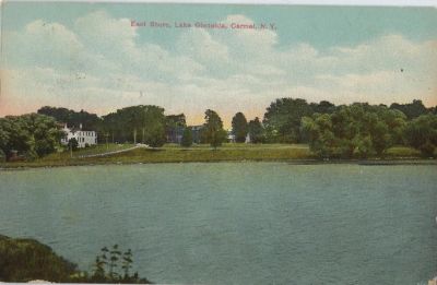
Many of the buildings once standing along Lake Gleneida were moved.